


 Energy


25 October 2024
Nestled in a natural bowl surrounded by hills 50km north-west of Johannesburg, the Hartebeesthoek Radio Astronomy Observatory (HartRAO), with its collection of radio dishes, looks quite out of place.
The road that snakes towards the observatory’s security entrance seems to conspire with the surrounding hillsides to hide the facility below, obscuring the site in an invisible layer of insignificance – except for the dishes that give away that something technologically advanced is taking place in this unlikely corner of the country.
The work that happens at HartRAO — which is a facility of the South African Radio Astronomy Observatory — is critical, however: the site plays a big role in ensuring the navigation systems used by people all over the world are accurate and reliable, while also contributing to advancing our understanding of the universe.
Geodesy is about finding the shortest distance between two points in n-dimensional spacetime
It was during a recent tour of HartRAO that TechCentral learnt that Johannesburg “bobs up and down” by around 30cm each day (along with the rest of the planet at between 20cm and 40cm). These “solid earth tides”, which cause the Earth’s mantle to ebb and flow like oceanic tides, are due to the gravitational forces exerted on the planet by the moon and sun.
Since this changes the position of a point on Earth’s surface, albeit only slightly in the grand scheme things, it has a significant impact on the accuracy of systems like GPS.
This is the explanation from Roelf Botha, manager of the space geodesy project at HartRAO. “Geodesy is about finding the shortest distance between two points in n-dimensional spacetime,” Botha said in an interview at the facility.
Unique
“As a modern society, the ability to navigate underpins everything. For that, position is very important, because if you know where you are and you know where you want to be, then a system like Google Maps … can figure out a route that tells you which way to go.”
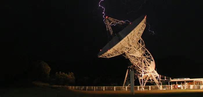
HartRAO is unique in that it is one of only seven such stations in the world known as “fundamental sites”. These are locations where all four of the major space-geodetic techniques are collocated.
The first of these techniques is very long baseline interferometry (VLBI), which uses a giant, 26m-wide radio telescope at HartRAO. Built in the 1960s, it was the first structure erected at the site by Nasa. VLBI is used to determine Earth’s position in space and the site’s position on the planet. This position is the reference then used in other geodetic techniques.
Please first to comment


Stay Connected
Tweets by elonmuskTo get the latest tweets please make sure you are logged in on X on this browser.